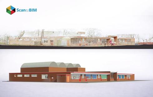
HBIM represents cultural heritage, architectural ingenuity and craftsmanship shaped by earlier civilizations. Stone masonry, timber framing and ornamental carvings reveal construction traditions that define regional identity. Many heritage structures exist without reliable design documentation which increases the complexity of preservation planning. Environmental exposure, material aging and urban pressures gradually influence structural stability across decades. Traditional documentation approaches depend on manual surveys that record limited measurements. Digital engineering introduces new documentation capabilities through reality capture technologies that generate detailed spatial records of historic structures.
Point cloud to BIM for historic buildings integrates laser scanning and photogrammetry with heritage science. Survey teams deploy terrestrial scanners that collect millions of spatial coordinates from architectural surfaces. These coordinates form dense point clouds that represent geometry with high precision. Software platforms process the dataset and convert spatial measurements into parametric BIM elements. Architects, engineers, and conservation specialists analyze the resulting digital twin to study structure, material distribution, and architectural composition.
This digital workflow transforms raw spatial data into intelligent building models through scan to BIM conversion. Point clouds provide the geometric reference that guides parametric modeling. BIM platforms translate measured geometry into walls, columns, vaults, and decorative assemblies. The resulting digital twin functions as a foundation for structural analysis, documentation, and preservation planning.
Importance of Accurate Documentation for Historic Construction Structures
Historic buildings present irregular geometries shaped by centuries of settlement, structural modification and handcrafted construction. Masonry walls display subtle curvature, timber beams reveal gradual deflection, and vaulted ceilings form non-orthogonal spatial relationships. Traditional survey approaches capture only a limited number of measurements. This restricts the understanding of real structural behavior. Digital documentation introduces precise spatial records that reflect the true geometry of heritage structures. Laser scanners capture millions of measured coordinates across surfaces, joints, and decorative elements. These datasets provide architects and engineers with detailed information required for restoration design, deformation analysis, and material evaluation within historic environments.
Accurate documentation provides measurable value across heritage conservation workflows:
- Detailed records reveal structural alignment, settlement patterns, and architectural proportions.
- Digital geometry supports structural assessment and engineering simulations.
- Conservation professionals reference recorded profiles during restoration of carved stone or timber assemblies.
- BIM based archives preserve architectural data for research, maintenance planning, and future reconstruction.
- Shared digital models improve collaboration between architects, engineers, historians, and conservation authorities.
- High-resolution spatial records assist project teams during adaptive reuse and renovation planning.
Accurate documentation transforms heritage preservation into a data driven discipline. High-fidelity spatial records capture geometry that manual surveys struggle to represent in irregular historic environments. Architects extract sections, elevations, and deformation maps directly from digital models. Engineers analyze structural behavior through precise geometric input. Conservation teams compare restoration proposals against documented conditions. Digital archives preserve architectural knowledge for future generations and guide responsible intervention across historic landmarks.
How Scan to BIM Technology Supports Historic Preservation
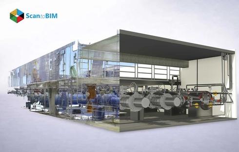
Historic preservation demands precise understanding of structural condition, material behavior, and architectural geometry. Reality capture technologies provide this precision through high-density spatial measurement. Laser scanners record mesh data across walls, vaults, columns and decorative surfaces. Each measurement documents the exact location of masonry joints, plaster profiles and carved stone details. The resulting point cloud forms a geometric reference that guides digital modeling. BIM specialists interpret these measurements and construct parametric building components that represent structural systems and architectural assemblies. Engineers study deformation patterns, settlement behavior, and material displacement through digital analysis within the BIM environment.
The methodology known as scan to BIM for historic buildings combines non-contact measurement with intelligent parametric modeling. Laser scanners emit pulses that calculate distance and angle to record accurate surface geometry. Each recorded point contributes to a detailed spatial dataset representing domes, arches, sculptural ornamentation and vaulted ceilings. BIM platforms translate this geometric dataset into digital building elements that represent historic construction assemblies. Engineers evaluate structural performance through simulation tools embedded in the model environment. Architects visualize restoration strategies by reconstructing damaged architectural elements through parametric components aligned with the captured geometry.
Digital replicas guide restoration planning, structural assessment, and conservation strategies. Engineers evaluate load paths, architects test restoration assemblies and preservation teams document architectural heritage within a shared BIM environment.

Laser Scanning and Point Cloud Data for Heritage Buildings
Laser scanning hardware forms the technical foundation for accurate heritage documentation. Terrestrial laser scanners emit controlled laser pulses that measure the distance and angle to architectural surfaces. Each pulse records a detailed spatial coordinate and millions of coordinates form a dataset known as a point cloud. This dataset represents the geometry, surface variation, and architectural alignment of a historic structure. Phase shift scanners capture extremely dense data across short ranges and record ornate architectural features such as cornices, moldings, and carved stone panels with sub-millimeter resolution.
Time of Flight scanners operate effectively across long distances and capture exterior façades, towers and masonry fortifications. Survey teams position scanners at strategic intervals across interior rooms, corridors and exterior courtyards. Overlapping scans create redundant coverage that strengthens spatial accuracy and improves registration performance during data processing.
The point cloud to BIM workflow begins during field data acquisition and continues through several structured processing stages. Survey teams capture overlapping scans that record geometry from multiple perspectives and registration software aligns these scans into a unified coordinate framework through iterative algorithms. Colorized point clouds generated from integrated cameras assist in material identification across stone, timber, plaster, and metal surfaces. Technicians clean and segment the dataset to remove noise and temporary site objects before importing the data into BIM platforms.
Modeling specialists reference the registered point cloud as a geometric template and trace structural elements directly from measured surfaces. Parametric components represent walls, arches, columns, vaults and roof systems with high geometric fidelity. The completed BIM model forms a precise digital twin that supports documentation, engineering analysis and restoration planning for heritage architecture.
Key Benefits of Scan to BIM for Historic Building Projects
As-built BIM models for existing buildings provide a reliable digital foundation for restoration planning, structural analysis, interdisciplinary collaboration and long term heritage asset management across complex historic environments.

- Captures highly accurate measurements and detailed architectural geometry.
- Accelerates site documentation compared with traditional surveying workflows.
- Supports structural load calculations and engineering analysis.
- Enables data driven decision making during restoration planning.
- Improves coordination among architects, engineers, historians, and conservation teams.
- Reduces repeated site visits through complete spatial capture in a single survey campaign.
- Provides Highly Detailed 3D visualization of complex heritage structures.
- Produces accurate documentation for reconstruction and conservation activities.
- Supports digital asset management and long-term facility maintenance.
Challenges in Modeling Historic Buildings from Point Clouds
Non-Standard Elements
Historic architecture features ogee arches, carved capitals and handcrafted brackets. BIM specialists create custom parametric families to represent eighteenth and nineteenth century architectural components accurately.
Irregular Geometry
Historic structures contain leaning walls, warped beams and uneven floors. Modelers interpret dense point clouds to represent structural deviations through adaptive parametric geometry within BIM environments.
Complex Surfaces
Decorative stone carvings, sculptural reliefs and curved cornices require mesh to BIM modeling techniques. High density meshes derived from point clouds guide accurate representation of intricate organic geometry.
Data Occlusion
Survey environments contain narrow corridors, vaulted ceilings and hidden cavities. These conditions produce partial datasets that require additional scans and careful interpretation during modeling.
Restricted Access
Heritage conservation regulations and fragile surfaces limit scanner placement. Survey teams design strategic scan layouts to capture geometry across sensitive historic environments.
Large Data Volumes
Point cloud datasets contain billions of spatial coordinates. High-performance workstations process this data during registration, visualization and parametric modeling tasks within BIM platforms.
Historical Alignment
Archival drawings and historical documentation may differ from measured geometry. Modelers compare digital scans with historical references to interpret structural modifications across centuries.
Authenticity Balance
BIM modeling requires accurate geometry and historical fidelity. Specialists interpret point clouds carefully to represent structural conditions and architectural character within digital heritage models.
Best Practices for Historic Building Scan to BIM Projects
Successful heritage documentation begins with detailed pre-survey assessment and strategic scan planning. Survey teams evaluate architectural complexity, access points, and coverage requirements before field deployment. High-overlap scanning from multiple positions captures every surface with strong geometric continuity. Hybrid data acquisition using terrestrial laser scanning, photogrammetry and UAV imaging records rooftops, towers and intricate façades. Colorized point clouds assist specialists in identifying materials such as stone, plaster, and timber during modeling. Technicians calibrate scanners and perform registration checks to maintain millimeter-level accuracy.
BIM teams create clear LOD targets and standardized parametric modeling guidelines for heritage components. Integration of archival drawings, photographs and historical records supports the digital model with contextual information. Open BIM standards such as IFC allow interoperability across design platforms and support collaborative restoration workflows.
Applications of Scan to BIM in Heritage Conservation
Heritage building BIM modeling supports structural evaluation, restoration planning, digital documentation, adaptive reuse strategies, and immersive heritage visualization through intelligent models derived from high-precision reality capture.
- Structural deformation monitoring of historic structures
- Restoration planning and intervention simulation
- Digital documentation and cultural heritage archives
- Adaptive reuse planning for historic properties
- VR and AR heritage visualization experiences
- Facility management and maintenance monitoring
- Architectural research using digital heritage models
- Tourism engagement through interactive heritage models
How Scan to BIM Supports Different Stakeholders in Heritage Conservation
| Stakeholder | Key Application |
|---|---|
| Architects | Visualize historic geometry and test restoration concepts |
| Structural Engineers | Analyze deformation, settlement, and load paths |
| Conservation Specialists | Document heritage elements and monitor deterioration |
| Surveyors | Capture accurate spatial data and generate point clouds |
| Owners / Facility Managers | Maintain digital records for long-term building management |
| Contractors | Access accurate geometry for restoration and repair work |
Choosing the Right Scan to BIM Partner for Historic Buildings
A qualified Scan to BIM partner demonstrates deep expertise in heritage documentation, advanced reality capture, and high-LOD parametric modeling. Experienced providers like ScantoBIMOnline estimate scan to BIM project cost through evaluation of architectural complexity, decorative density, and modeling detail rather than simple square footage. Firms with strong portfolios show accurate digital reconstruction of arches, vaults, and sculptural elements. Proven experience with heritage regulations and restoration workflows provides additional confidence for preservation architects and VDC managers.
Professional scan to BIM outsourcing firms maintain advanced hardware capability and field expertise in laser scanning for historic buildings. Survey teams deploy high precision scanners to capture intricate carvings, vaulted ceilings and fragile masonry surfaces. Strong partners deliver accurate point clouds, structured BIM models and consistent quality control reporting.
Conclusion: Preserving Historic Structures with Digital BIM Models
Historic preservation now depends on data-driven documentation. The process helps in capturing geometry, material behavior, and structural conditions with high precision. As-built BIM for historic buildings transforms point cloud datasets into intelligent digital twins. The scan to BIM process supports restoration design, structural simulation, and facility management. These models convert fragile heritage archives into living engineering assets used by architects, conservationists, and VDC teams. Organizations that adopt Scan to BIM workflows gain a measurable framework for protecting historic structures and guiding responsible restoration initiatives.
Frequently Ask Question
1. How much does Scan to BIM cost for historic building documentation?
We calculate project pricing based on architectural complexity, scan coverage and modeling detail. Historic structures often include arches, carvings and irregular geometry that require custom BIM components. After reviewing drawings or performing a quick site assessment, we provide a clear project quotation.
2. Is laser scanning safe for fragile or protected historic structures?
Yes. Non-contact laser scanners are used that capture measurements using light pulses from a distance. The survey team positions scanners carefully around sensitive areas to document surfaces without touching them. This method allows capturing fragile carvings, frescoes and masonry safely.
3. Can Scan to BIM capture intricate architectural details like ornaments and carvings?
Absolutely. High-resolution scanners capture millions of measurement points across decorative elements such as cornices, sculptures, and moldings. During modeling, our BIM specialists interpret this point cloud data and build detailed components that accurately represent those historic architectural features.
4. How accurate are BIM models created from laser scans of historic buildings?
Our AI-powered laser scanning workflow delivers millimeter-level accuracy. After registering the scans, we build BIM elements directly against the point cloud reference. This process allows architects and engineers to work with highly reliable models for restoration planning and structural evaluation.
5. What challenges arise when scanning and modeling very old buildings?
Historic buildings often include leaning walls, uneven floors and handcrafted architectural elements. These conditions require careful scan planning and specialized modeling techniques. Our team creates custom BIM families and adaptive geometry using AI and ML to represent the building exactly as it exists.
6. How long does it take to complete a Scan to BIM project for a historic building?
The timeline depends on building size, accessibility and modeling level of development. The scanning team usually completes field capture within a few days. After processing the point cloud and developing the BIM model, most projects reach completion within several weeks, depending on the size and complexity of the project.
7. Can Scan to BIM data be used for restoration, renovation, and future maintenance planning?
Yes. We deliver BIM models that function as digital twins of the building. Architects use them for restoration design, engineers perform structural analysis and facility teams manage maintenance planning. The model also serves as a long-term documentation record.