Scan to BIM Conversion for Residential House in New York, USA
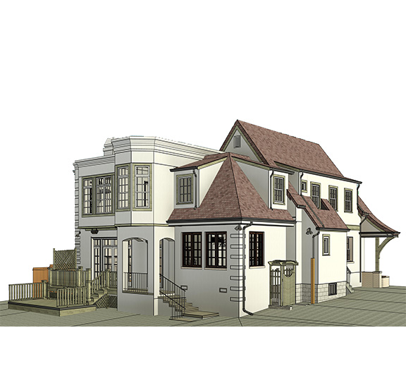
Accurate multi-disciplinary BIM model developed from point cloud data for a residential house of 10,500 sq. ft. delivered in just 8 days.
Project Overview
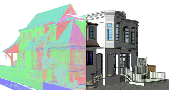
Traditional measurement methods struggle to capture complex curved walls and intricate architectural details in luxury residences, creating risks for accurate renovation planning. Whereas, raw laser scan data captures everything but lacks usability for design teams. Bridging this gap required careful interpretation and coordination. We transformed point cloud data into precise 3D as-built models for a 10,500 sq. ft. residential house, capturing architectural, structural, and MEPF elements. Consistency across plans, sections, and elevations ensured a reliable representation of existing conditions within the 8-day project timeline.
Scope of Work
Architectural
- Detailed floor plans for all levels
- Reflected ceiling plans with soffit heights
- Roof plan with drainage and slope annotations
- Exterior and interior elevation drawings
- Section cuts through key architectural elements
- Door and window schedules with openings
Structural
- Structural framing layouts
- Columns and beam modeling
- Staircase and slab documentation
- Roof structure modeling
MEPF
- Mechanical ductwork routing and equipment locations
- Electrical conduit runs, panels, and fixture positions
- Plumbing supply and drain lines with fixture connections
- Fire protection sprinkler layout
- Coordinated MEPF clash detection
Client Challenges We Solved
Complex curved walls and façade geometry
Cross-discipline plan, section & elevation coordination
Consistent documentation accuracy across all trades
Scan clutter obscuring fine architectural detail
Incomplete MEP data requiring informed interpretation
Exterior surface accuracy in dense urban context
Project Execution Challenges & Approach
Challenge
- Site obstructions and scan clutter
- Complex curved and irregular geometry
- Incomplete or hidden MEP elements
- Exterior scan data accuracy
- Maintaining quality within tight timeline
Approach
- Manual interpretation of point cloud data with cross-section validation.
- Iterative modeling with multi-pass validation checks against scan references.
- Referenced available scan data; applied standard assumptions where gaps existed.
- Cross-verified point cloud against 360° panoramas and multiple scan positions.
- Parallel workflow execution across architectural, structural, and MEPF disciplines.
Project Inputs and Deliverables
Key Outcomes
Business Impact
"The precision of the as-built drawings was excellent, especially given the complex layout of the home. The team managed to turn around a massive amount of data into clear, coordinated plans within a very tight window. Having such a reliable set of documents from the start has made our renovation planning much smoother and saved us a lot of time on-site."
Let's Convert Your Site Scan Into a Precise, Coordinated BIM Model
Contact us today and discover how our specialised multi-disciplinary AI-powered scan to BIM workflows can deliver accurate, renovation-ready documentation on time and to LOD specification.
Claim Your Free Pilot Before You CommitContact Us
Let’s discuss your requirements and see how our expertise can help
on your next project.