Point Cloud to BIM for Surveyors: Workflow & Accuracy Guide
Surveyors face increasing demand for accurate, highly detailed digital deliverables. Point cloud data offers a direct pathway from physical site conditions to structured 3D models. This guide covers every stage from scanner setup to verified BIM output, helping survey professionals achieve measurable project success.
Introduction to Point Cloud to BIM for Surveyors
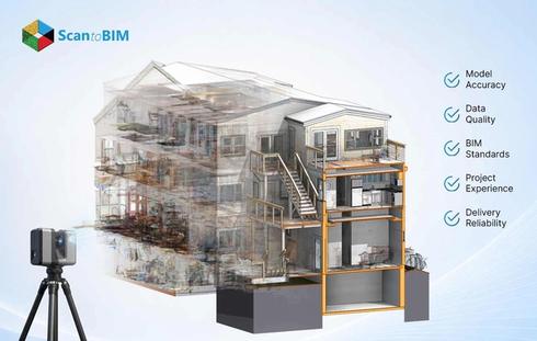
Scan to BIM converts scanned spatial data points into structured 3D models. These models carry embedded information, materials, dimensions, and functional data that support the full project lifecycle. For survey professionals, this marks a clear shift away from traditional measurement methods. Digital workflows now deliver real, measurable project value.
The shift is reflected in the wider industry numbers. According to Fortune Business Insights , the global building information modeling market was valued at USD 9.12 billion in 2025 and is projected to reach USD 27.12 billion by 2034, growing at a 12.90% CAGR. Surveyors who deliver BIM-ready outputs are positioned directly inside that growth curve.
The success of any laser scan to BIM project depends on two factors. Accurate field data forms the first foundation. Expert modeling of that data forms the second part. Renovation, retrofit, and heritage projects gain the greatest advantage from this workflow. Particularly where existing drawings are outdated or unavailable.
How Surveyors Capture Data Using Laser Scanning
Laser scanning for surveyors starts with positioning equipment at multiple stations across the site. Terrestrial laser scanners emit pulses from a fixed position. Each pulse returns after contacting a surface. The system calculates exact XYZ coordinates for every return point. SLAM technology extends this capability further. Operators walk continuously through a space to capture data at every step. Both technologies produce raw scanned files that can reach hundreds of gigabytes in size.
Core Scanning Technologies Used by Surveyors:
- Terrestrial Laser Scanners: Fixed position capture for structural and architectural surveys
- SLAM Mobile Scanners: Continuous walk-through capture for large or complex interior spaces
- Aerial LiDAR Systems: Topographic surveys and large site coverage documentation
- Photogrammetry Systems: Image surface capture for exterior facade documentation
- Hybrid LiDAR Systems: Combined capture for maximum coverage across complex sites
Surveyors plan scanner positions carefully to address occlusion areas where physical obstructions block the laser path. Overlapping coverage across scan stations provides enough shared data for accurate registration. Scanning accuracy at this stage ranges from ±3 mm to ±10 mm, depending on the equipment selected and site conditions present.

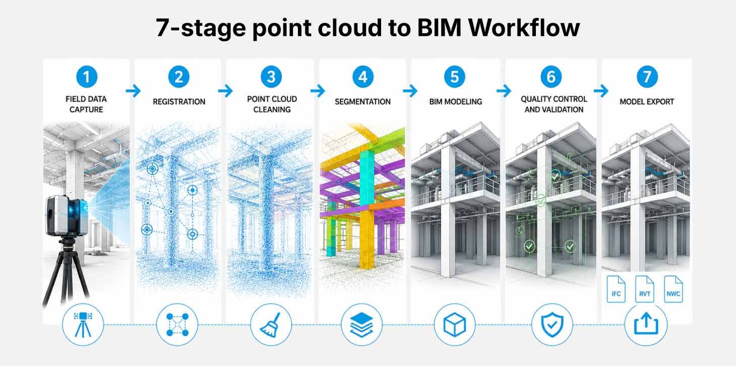
Point Cloud to BIM Workflow Explained
The point cloud to BIM workflow moves through seven structured stages. Each stage builds directly on the quality of work completed before it. Project teams that invest focused attention at every stage consistently deliver accurate, usable BIM outputs to clients.
Stage 1: Field Data Capture
Surveyors collect raw scan data using terrestrial or mobile laser scanning systems. The scanner records millions of XYZ data points representing the physical geometry of the building or site.
Stage 2: Registration
Software aligns multiple scan files into a single unified coordinate system. Tools such as Leica Cyclone Register 360 and FARO SCENE process this alignment. The registration error must stay within ±6 mm for standard BIM projects.
Stage 3: Point Cloud Cleaning
Operators clean the dataset by removing noise and irrelevant elements. Preserved raw data supports accurate error correction throughout the project.
Stage 4: Segmentation
The point cloud gets organized by building type and MEP components. This segmentation simplifies the modeling process by separating data into logical groups.
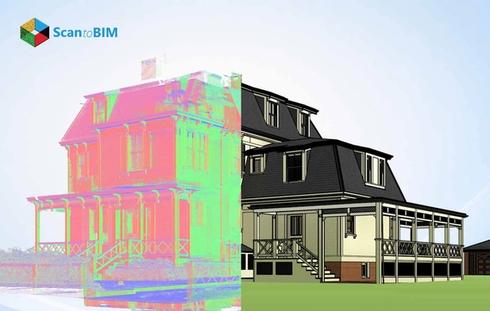
Stage 5: BIM Modeling
BIM modelers use software such as Revit to trace the scanned data. Semi-automated tools support faster parametric object creation. Each element reflects verified geometry from the field.
Stage 6: Quality Control and Validation
The BIM model gets overlaid onto the original point cloud. A QA reviewer analyzes deviations through section views and comparison tools. The model meets the project-defined tolerances before delivery.
Stage 7: Model Export
The team exports the final model in formats such as RVT or IFC. These outputs serve downstream design and coordination workflows, alongside facility management applications.
Role of Survey Data in BIM Modeling
Survey data to BIM modeling begins with georeferencing. This process anchors the digital model to real-world coordinates. Surveyors place control points across the site before scanning begins. These control points carry verified coordinates from a national geodetic datum. Accurate control point placement defines the spatial accuracy of every modeled element.
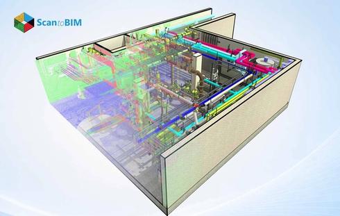
The LiDAR data acts as the primary reference throughout the full modeling process. Design teams draw decisions from this verified spatial information rather than outdated drawings or assumptions. BIM modeling from point cloud data creates accurate representations of structural and MEP elements within one shared digital environment.
Survey data also supports clash detection in the digital model. Potential conflicts between building systems appear before construction activities begin. Material estimates and cost projections drawn from verified survey data carry higher confidence. The level of detail modeled for each element reflects the quality of the survey data received by the BIM team.
Accuracy and Tolerance in Point Cloud to BIM
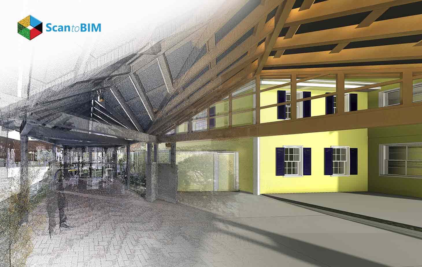
Accuracy in LiDAR to BIM measures how closely the final model reflects the real structure. Deviation analysis quantifies this relationship at the project start. High-accuracy structural projects operate at tolerances within ±2 mm to ±5 mm. Standard architectural renovation projects accept tolerances in the ±5 mm to ±10 mm range.
The capability ceiling is even higher with modern equipment. Autodesk reports that a single laser scan can cover up to 100,000 square feet of space per day, and the highest levels of detail in scan to BIM workflows offer a tolerance range of a single millimeter or less accurate enough to fabricate carbon copies of building features. That ceiling is the reason heritage and high-precision structural projects increasingly demand laser scan deliverables over traditional measurements.
A scan to BIM service team must agree on accuracy parameters with the survey crew before modeling begins. Scanner quality shapes the initial data. A modeler's skill shapes the final interpretation. A structured QA/QC workflow with intermediate reviews catches deviation errors before final delivery. Preserved raw data allows modelers to revisit discrepancies throughout the project lifecycle.
Key Factors That Influence Point Cloud to BIM Accuracy:
- Scanner calibration status and resolution settings
- Registration error between overlapping scan stations
- Control point accuracy and geodetic survey network quality
- Modeler expertise in interpreting ambiguous or complex scan areas
- QA/QC validation frequency during the modeling stage
- Communication clarity between the survey and modeling teams
Benefits of Point Cloud to BIM for Surveyors
- Fewer Site Visits: A single scanning session captures all geometry needed for full model creation
- Faster Documentation: Structured workflows from 3D BIM models accelerate as-built delivery timelines
- Higher Model Accuracy: Laser-captured geometry removes estimation errors common in manual measurement
- Improved Team Collaboration: A shared BIM model gives all project stakeholders access to verified spatial data
- Client Visualization: 360-degree visual outputs help clients understand existing spatial conditions with clarity
- Lifecycle Digital Asset: The model supports maintenance, upgrades, and renovation planning for years ahead
- Market Advantage: Surveyors delivering BIM-ready outputs command stronger value in the project market
Common Challenges in Surveyor BIM Projects
Understanding the known scan to BIM challenges helps project teams prepare effective mitigation strategies before fieldwork begins.
Data Volume Management
Point cloud files reach hundreds of gigabytes in size. Storage infrastructure and processing hardware must meet this demand before fieldwork begins. Teams that plan for data management from the project start avoid costly delays later in the process.
Occlusions and Coverage Gaps
Physical obstructions block the laser path during scanning. Additional scan positions or a planned resurvey fill coverage gaps. Surveyors address this risk during initial scan planning before a single point gets captured on site.
Complex Geometry Interpretation
Heritage structures present irregular geometry that challenges standard modeling workflows. Modelers need construction knowledge alongside BIM expertise to interpret these areas with accuracy. Industrial sites present similar challenges with curved or non-standard structural forms.
Coordinate System Misalignment
Errors in georeferencing at the project start cascade through every modeling stage. Verification of control point accuracy before data handoff prevents this issue from compounding. The survey team must confirm geodetic alignment before the scan files are transferred to the modeling partner.
Skill Gap Between Survey and Modeling Teams
Survey firms may capture excellent field data. The gap appears when that data reaches an inexperienced modeling partner. This disconnect is one of the core issues that affects final deliverable quality, from registration accuracy to model geometry.
Poorly Defined Project Scope
Vague project briefs create mismatched expectations between the survey team and the BIM partner. A detailed project execution plan at the start prevents scope conflicts and costly rework later in the process.
Best Practices for Surveyors Using Point Cloud Data
Scan to BIM for surveyors works most effectively when the full project scope is defined before scanning begins. Confirm the LOD requirement for every building element in a written scope document. Specify the deliverable format and target coordinate system with the BIM partner at project kickoff. Clear pre-project alignment removes ambiguity for every team member involved.
Preserve scanned data throughout the full project lifecycle. Retain all original scan files even after cleaning and registration are complete. Modelers who access original raw data resolve interpretation issues without a return site visit. Organize large datasets by floor or section to maintain software performance during the modeling stage.
Select a Point cloud scan to BIM partner with demonstrated QA/QC processes. Request sample deliverables from comparable project types before committing. A review of the partner's registration workflows confirms technical capability. Continuous training in scanning disciplines keeps survey firms competitive as project complexity grows.
Conclusion
Reality Capture to BIM gives surveyors a structured path from field reality to intelligent digital deliverables. The workflow demands equal attention at every stage from scanner positioning to final model validation. Accuracy in the field means little without expert interpretation at the modeling stage. Survey professionals who invest in quality data capture alongside capable BIM partnerships consistently deliver projects that meet client expectations.
Understanding the point cloud to BIM cost implications early helps teams allocate resources to the stages that matter most. A well-executed BIM model becomes a long-term digital asset for the building owner. It supports facility management and lifecycle decisions for years ahead. Surveyors who adopt this workflow today build stronger client relationships and more sustainable project pipelines for the future.